
News - Bitter Cold Grips Michigan: Advisory Issued Through Saturday
Business Strategy
Bitter Cold Grips Michigan: Advisory Issued Through Saturday
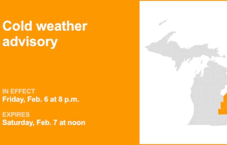
In response to a surge of frigid temperatures, the National Weather Service released a cold weather advisory early Friday morning for parts of Michigan. Affecting Huron, Tuscola, Sanilac, Genesee, Lapeer, St. Clair, Livingston, Oakland, and Macomb counties, this advisory anticipates harsh wind chills reaching as low as 20 degrees below zero. These conditions present a significant risk of frostbite within 30 minutes of exposed skin contact. To mitigate risks, residents are urged to dress warmly, including hats and gloves, and limit time outdoors. Those utilizing portable heaters should do so responsibly, and generators must not be operated indoors. Communities are encouraged to check on vulnerable individuals, such as the elderly or those without proper heating. Understanding various levels of cold weather alerts is crucial for safety: A 'Cold weather advisory' signals the need for awareness of forecasts indicating seasonably cold but not extreme temperatures. When activated, appropriate protective clothing should be worn, and exposure minimized. An 'Extreme cold warning' necessitates immediate action, signaling hazardous wind chills or air temperatures. Residents should remain indoors where possible, wear layers, and inform someone of their whereabouts. An 'Extreme cold watch' suggests preparation for potential dangerously low temperatures or wind chills, advising alterations to outdoor activities and ensuring vehicles and home safety kits are ready for winter conditions.
About usyoo

Categories
Tags