

News - Severe storms and humidity return to Michigan
Business Strategy
Severe storms and humidity return to Michigan
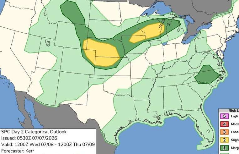
As storm systems roll into Michigan, residents are advised to prepare for a wet and humid week. The state's Upper Peninsula and parts of the northern Lower Peninsula are bracing for thunderstorms on Tuesday, July 7. These storms signal the arrival of a broader weather front that will bring additional rain across the region starting Wednesday, July 8. The National Weather Service forecasts that the inclement weather will extend into Thursday, July 9, with widespread showers expected to drench the Lower Peninsula. Tuesday, July 7, will see temperatures range between 70°F to 80°F across Michigan, climbing slightly by Wednesday as cities in the central Lower Peninsula may touch the 90°F mark amid escalating humidity levels. As the week progresses, meteorologists predict that Wednesday's showers could affect most of Michigan, especially the northern Lower Peninsula, which faces a heightened risk of severe weather. According to the National Weather Service office in Gaylord, 'Dry and warm weather today (July 7) gives way to increasing shower and thunderstorm chances Wednesday (July 8) into Thursday morning (July 9). Some of these storms could produce some brief heavy rains, with any repeated storms across the same area resulting in some locally heavy rain totals.' Residents are urged to closely monitor weather updates and remain vigilant as the potential for heavy rainfall looms. Authorities have provided resources such as Michigan's live Doppler radar and current warnings, watches, and advisories to keep the public informed. For those needing more information or updates, stay connected via local weather channels or follow official sources like the National Weather Service. Be prepared and stay safe as Michigan weathers the storm.
About usyoo

Categories
Tags